It was interesting to see this recent story from Dublin, GA:
Dublin tries a new way to reduce speeds: a ‘road diet.’ Here’s what that is
While it doesn’t fully capture the neighborhood greenways concept Ride Robins is advocating, it’s much closer than anything under discussion in Houston County. The model of residents engaging to have their streets part of a safe streets program is something we envision for our community. It will improve safety and livability. That level of engagement will be needed to create a robust active transportation network built on a foundation of neighborhood greenways in the Robins Region.
As a tactical matter, we’ve avoided promoting road diets. This is not because there aren’t some in the Robins Region which would make a lot of sense, but because there are other near term projects which would be less dramatic, and probably less controversial.
Controversy is not always a question of reality, but often of perception. More lanes does not mean less traffic. Road diets often draw opposition due to the perception that one less lane will mean more traffic, but this is not usually the case.
Since Dublin’s road diets were recently in the news, it might be time to explore which roads in the Robins Region could be a candidate for a road diet. This is not a comprehensive list, but here are three, and one we’ll explore in more detail:
South Corder Road

Google Maps
This four lane road with no middle turn lane has a posted speed limit of 35 mph. No one drives 35. It’s fast, hilly, curvy, and dangerous.
Cohen Walker Drive

Google Maps
This four lane boulevard serves numerous government offices, schools, and youth oriented activity centers. Its 35 mph speed limit is commonly ignored, especially by high schoolers racing to school in the morning.
North Davis Drive

Google Maps
Here is a map showing the percentage of households in the Robins Region without an automobile:

Note the red and orange in the northeast quadrant of Warner Robins. North Davis Drive serves an area of Warner Robins where you are most likely to see people biking for transportation. These are fietsers. And this important stretch of road, which directly connects to Commercial Circle and a future downtown Warner Robins, is ripe for reawakening.
Here is a map from the Georgia DOT showing annual average daily traffic counts – AADT:

At less than 10,000 ADT, some of North Davis Drive is a great candidate for a road diet, and capacity will most likely not be affected, while closer to Commercial Circle it remains still a good candidate. Considering the social and economic potential, and overall inexpensive cost, a road diet in this location could provide more to gain than to lose, and potentially serve 27,000 people/hr, at least according to streetmix.net.
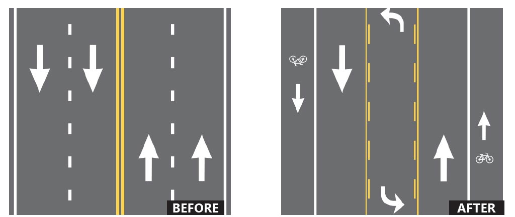
What could a new North Davis Drive look like?
The street itself is forty feet wide. There are four drive lanes, two headed north and two headed south. Each lane is ten feet wide. Using the same forty feet, here’s one idea of what we could have instead. Whatever a final design, an engineer, given the right call to action, could make this work better for more users. Should someone tell them to?


Leave a comment