

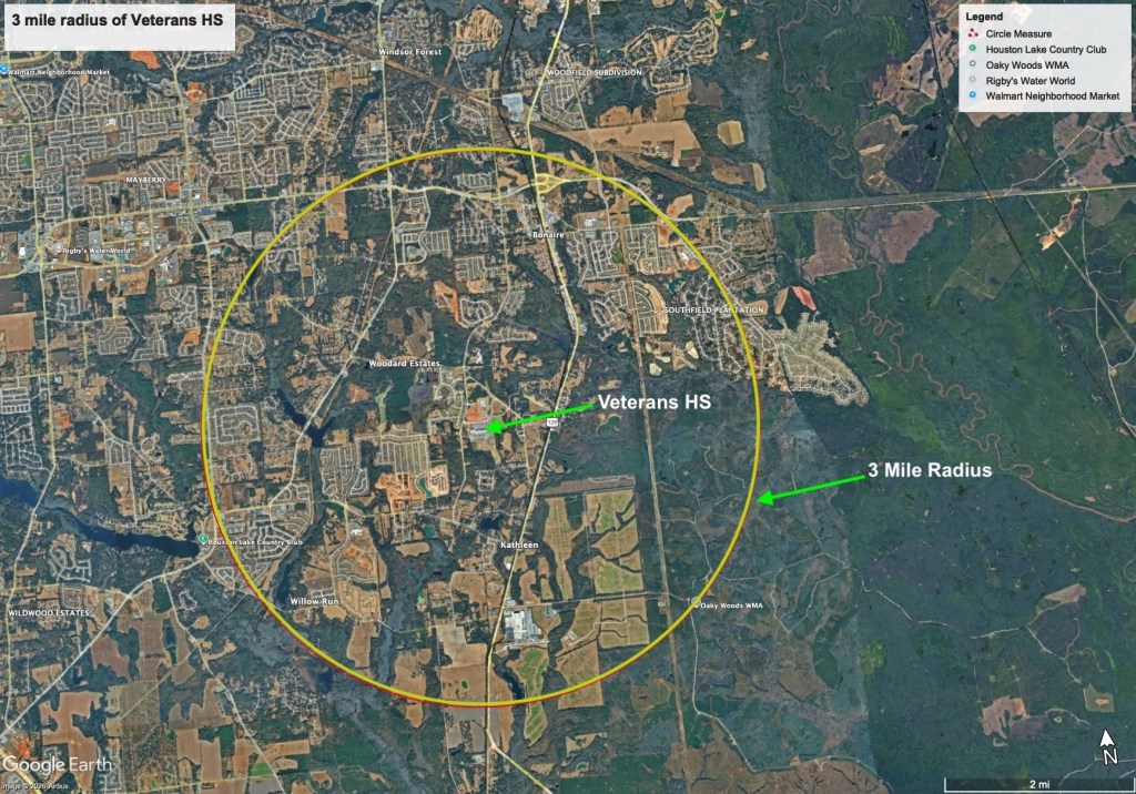
Traffic around Veterans High School is a legitimate concern on school days. Now, Houston County is preparing to open Veterans Middle School next door to the high school in 2027, with a proposed attendance zone of roughly 756 students. About 554 would come from the current Bonaire Middle zone and about 202 from Perry Middle. (content.myconnectsuite.com)
The predictable public response: We need a traffic study.
Maybe we do.
But if we study only traffic, we’ll get bigger roads yet miss the bigger question:
How might students get to school?
Any discussion about the Veterans High and Middle School campus should prioritize Safe Routes to School and connectivity to nearby neighborhoods.
Count students, not cars
Two years ago, Ride Robins asked Houston County Schools how students get to school?
The district told us it did not know the percentage of students at individual schools who walk, bike or arrive by car. It did provide information about school-bus transportation.
That’s an important knowledge gap.
Before deciding how much road capacity we need, we should know how many Veterans High students drive themselves, get dropped off, take the bus, walk or bike. We should know it for the middle school too.
Perhaps the student environmental clubs could help us find out?
And more so…
How many students would walk, bike or roll if they had a safe way to do it?
The Woodlands isn’t just part of the traffic. It can be part of the network.
Look at a map around Veterans High and the new middle school.
The Woodlands sits directly across from Veterans High. Its streets already form a substantial residential network beside the campus. (mischathompson.com)
Every school trip from that neighborhood made by car becomes another vehicle on Old Perry Road. But those same neighborhood streets could carry walking and biking trips. So, instead of asking merely how quickly cars can move from The Woodlands to the school, ask:
Could a student get there safely without entering the traffic stream at all?
Maybe the missing piece is a crossing.
Maybe it’s a short path.
Maybe it’s another entrance into the school campus.
Maybe two neighborhood streets almost connect but don’t.
That’s what a connectivity study would find.
And The Woodlands is only one example. We should ask the same questions of neighborhoods in every direction.
Slower and smoother
If Old Perry Road becomes congested twice a day, adding more vehicle capacity shouldn’t automatically be the answer.
Around two schools and surrounding neighborhoods, a better goal may be slower, calmer and more predictable traffic.
That’s what we mean by slower and smoother.
Houston County meeting minutes have described Old Perry Road in this area as a 45-mph road. In 2025, the county approved new reduced-speed school-zone flashers at Veterans High. (houstoncountyga.gov)
With a middle school being added, this is the time to look at the road itself.
Could the approach to the schools be designed around something closer to 35 mph?
Could the immediate school area be designed so 25 mph feels natural instead of depending primarily on signs and flashers?
Could turning movements, crossings and school entrances be designed to reduce conflicts and sudden stops?
Is all of the existing pavement being put to its best use?
Could some of it provide safer walking and biking access?
The goal isn’t to make traffic slower for the sake of making it slower. It’s to make the whole corridor safer, more predictable, and more efficient for everyone.
Those questions belong alongside vehicle counts, turning movements and queue lengths.
Think big by thinking small
A connected school network doesn’t necessarily mean miles of expensive new trails.
It may mean fixing a handful of small gaps:
A short connection between two neighborhoods. A safer crossing. A missing sidewalk. A few hundred feet of shared-use path. A neighborhood entrance into the school grounds. Secure bicycle and e-bike parking.
One small connection can make miles of existing neighborhood streets useful. As well, any ideas can be tested with inexpensive off-the-shelf materials before committing to permanent construction.
To think big about connectivity, sometimes you have to think small.
Two miles — and then three
Georgia’s Safe Routes to School guidance already provides a framework.
It recommends mapping students within ½ mile, 1 mile, 1½ miles and 2 miles of a school; identifying walking and biking routes; examining sidewalks, trails, crossings and traffic speeds; and observing school arrival and dismissal. (dot.ga.gov)
Let’s start there.
But because Veterans Middle and Veterans High serve older students, Ride Robins proposes going one mile farther:
Three miles.
Not because every student will walk three miles.
But three miles is a very different trip on a bicycle, e-bike or other form of micromobility. For many students, it can be a 10- to 15-minute trip, competitive with waiting for a school bus, or even a car ride through traffic.
Students are going to use bicycles, e-bikes and other small vehicles. Planning for those trips doesn’t mean assuming everyone will use them.
It means recognizing that some will.
The question is whether they get a connected, low-stress route — or have to improvise on roads built almost entirely around cars.
A little more freedom for everyone
There’s another benefit that won’t show up in a traffic count:
Independence.
A safe route gives older students the freedom to make a short trip on their own — walking, biking or riding with friends — instead of depending on a parent for every trip.
And that freedom works both ways.
Every student who can safely get to school without being driven is one less morning or afternoon trip a parent has to make.
That’s more independence for the student, more time for the parent, more physical activity and fewer cars in the school line.
A safe route to school doesn’t just move a student.
It gives a family a little more liberty.
Use what we already have
Much of the network may already exist.
Neighborhood streets.
The job is to find the gaps between those streets, the surrounding subdivisions and the schools.
So the study shouldn’t stop at drawing a three-mile circle. It should map where students live and ask:
Where can neighborhood streets carry the trip?
Where does the network break?
Where is the dangerous crossing?
Where could one short connection unlock an entire neighborhood?
Where could a bike bus or walking school bus let students make the trip together?
Georgia’s Safe Routes to School program specifically provides resources for safe routes, bicycle trains and walking school buses. (dot.ga.gov)
Traffic is the symptom. The trip is the question.
A traditional traffic study asks:
How do we move the cars?
A Safe Routes to School and connectivity study asks:
How do we move the students?
Those aren’t competing questions. Houston County can study both.
But this is the moment to look at the whole system.
A new middle school is opening.
Attendance zones are changing.
Hundreds of students will begin making new daily trips.
And around the schools are neighborhoods and streets that may already provide much of the network we need.
The neighborhoods are already there.
The streets are already there.
The students are already there.
Now let’s find the connections.


Leave a comment